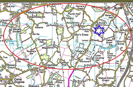
Area covered by the Forward
Ammunition Depot (FAD)
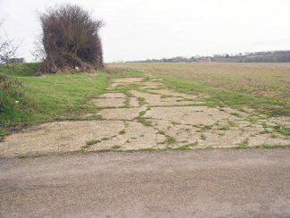
Motorists driving between White Colne,
Pebmarsh and Bures Hamlet, hardly give a thought to why these idyllic
country roads have such large lay-bys, broken concrete bases in the
grass verges and missing hedgerows.
|
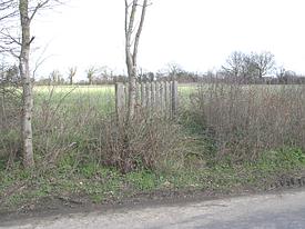
In one particular case, there is
a small wooden garden gate standing alone in a hedge that serves
no useful purpose and leads into an open field.
In reality, this gate led to a Nissen Hut which was the location
of an Administration Centre for the USAAF Transport Division.
The personnel controlled the flow
of traffic along all the roads between Bures and White Colne/Earls
Colne railway stations.
|
|
Locally this all started back in 1942
when the Americans arrived and started to survey the surrounding countryside.
One farmer, just outside Bures still recalls how the American "top
brass" arrived in a large staff car, parked outside and proceeded
unannounced to
wander around his land and the local area.
Were we destined for another airfield? With Wormingford airfield already
up the road, this seemed unlikely.
Subsequently, the local community learnt
that certain stretches of road were to be commandeered by the military
for use as storage depots. Nobody was sure what this really meant or
the implications.
During the Second World War, large quantities of munitions were produced
and imported and needed to be stored prior to use. In order to prevent
large ammunition dumps on airfields being destroyed by Luftwaffe bombing,
they needed to be stored well away from these targeted areas.
The rural area between Bures, Pebmarsh,
White Colne and Earls Colne could well have been the largest dispersal
site in the country that utilised normal public roads.
There were two other sites like this in East Anglia but on a much smaller
scale, Brandon and Earsham (Bungay)
The area west of the Bures, fulfilled the requirements of the military
in that:
(a)it was a location sufficiently remote from the airfields at Earls
Colne and Wormingford, which were prime targets for bombing;
(b)it was a location sufficiently close to the railway lines and airfields
to reduce transport time and cost;
(c)it was close to a railway line, with links to the main lines
(d) easy access for building materials, Ferriers Farm sand and &
gravel pit on site.
(e)the remoteness of the area meant that security could easily be maintained,
with little chance of strangers going unnoticed or unchallenged.
The network of roads was constructed by a large number of black-American
US Army servicemen. Local residents can still recall how they were made
to work outside under atrocious conditions, with little consideration
given to their welfare.
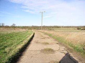 "The road to nowhere"
 |
 Access road into the FAD from Bakers
Hall
Access road into the FAD from Bakers
Hall |
The USAAF servicemen carried out road
construction; ditches were filled in with rubble and concreted over
to produce small areas of hard standing. These formed the storage bays,
which were spaced approximately 50-100 yards apart for safety reasons
Hardcore for the roads was obtained from the brick rubble cleared from
the bomb-damaged houses in London. A large number of lorries constantly
travelled between London and the surrounding countryside supplying the
insatiable demand for the road base material.
Evidence of this can still be found today with broken bricks and tiles
ploughed up in the fields.
Hardcore/rubble was also transported by train to White Colne railway
station, via Cambridge. The majority of this was used for runway building
at Wormingford & Earls Colne airfields.
Vast concrete mixers provided the top surface layer. The amount of aggregate,
hardcore and cement must have been on a gigantic scale when you appreciate
the amount of additional road and dispersal sites that were constructed.
The sand and aggregate was obtained locally from local pits at Ferriers
Farm and Alphamstone.
One local resident recalls it was near impossible to use the local roads
after seven in the morning because of the number of sand & gravel
lorries. Lorries rumbled thro` the villages from early morning until
dusk.
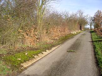
Existing public roads were widened and those
incapable of carrying any substantial weight, were reinforced with a layer
of concrete. A typical example is the road between Daws Cross and Countess
Cross, before the war was just a narrow dirt track but it was widened
and a skim of concrete poured over the top, it has no base material whatsoever
In other cases, a hastily constructed "by-pass" circumvented
roads with sharp 90deg corners. The large American lorries which
were to be used, couldn`t accommodate these tight corners. One of
these short by-passes which runs across farmland is known locally
as "Yankee Road" -
The right picture shows an example of this road together with a
war time Romney hut. |
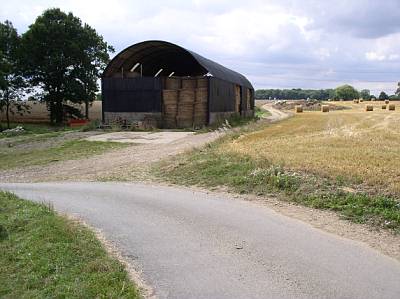 |
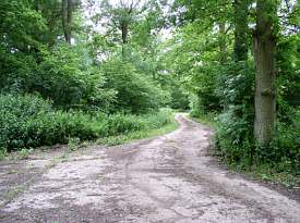
At Bakers Hall Bures, a complete road
system was built across farmland to facilitate the movement of trucks,
the erection of Nissen huts and guard posts.
| Evidence of these dispersal
bays are still known locally as the "bomb dumps" and can
still be seen today some 60 years later (picture). Broken concrete
slabs, wide verges and in many cases gaps in hedges are all evidence
of the work carried out by the USAAF. |
 |
|
Bombs of all sizes were then transported
along the roads and stacked on the areas of hard standing.
Picture taken on the Bures to Earls Colne Road
|
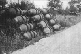 |
The stacks were then covered in camouflage netting. Hawthorn and other
trees along the roadside were left and acted as further camouflage to
prevent detection from the air.
Guard posts were erected at strategic
points around the area to form an impenetrable barrier to unwanted visitors.
Traveler's were stopped and questioned as to the nature and reason for
their journey. Local villagers were issued with "passes" in
order to traverse the area.
All footpaths were closed to the public by the Secretary of State for
Air on 2nd March 1943
The HQ for the entire dispersal area was located at "Wakes Hall",
on the main A604 (now owned by the charity SCOPE). This was the main
administration building and used for the issuing of passes, telephone
exchange etc
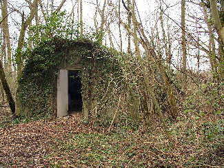
| Woods were very much
in demand as they were the ideal location to camouflage staff accommodation
and in one case the storage of "incendiary devices" It
would be difficult for the Luftwaffe to see these buildings hidden
amongst the trees. |
 |
| One very large wood
between Bures and Pebmarsh even had its own internal concreted road
system and housed something like 14 Nissen huts used by American
personnel. |
 |
Not all Nissen huts were used for staff
accommodation, others were used to house boxes of machine gun bullets
used by the bomber and fighter aircraft. These bullets were stored in
wooden boxes, which were often discarded by the Americans after they
were emptied or even smashed as they were thrown around.
Guards took little notice of local children playing, but if they only
realised what was hidden in that broken down pram they seem to constantly
wheel around - firewood from broken boxes of course.
The logistics for this work must have
been on a monumental scale as it was a 24hr operation. Ammunition was
being transported to the roads for storage whils`t in reverse other
material was being loaded up for onward transportation to the local
airfields. The roads were so congested a simple one way system was devised
to keep the traffic moving efficiently.
The entire area was officially known as the "Bures Ordnance Ammunition
Depot USAAF Station 526"
However, Essex County
Council records show the area around Bakers Hall farm as "Wakes
Colne RAF Station"
The Dispersal Site area extended south into White Colne. Not to be confused
with Wakes Colne which was given the name "Wakes Colne HHB, 19th
AAA" (Headquarters & Headquarters Battery and Anti Aircraft
Battery)
Last updated 2016